Archive for the ‘Cycling’ Category
The Ammer-Amper Radweg (AAR), Bavaria
 Leave a comment
Starnberger See from Gasthof Cafe Seeseiten
I am trying to get my fitness up to a decent level. I always feel that I should be able with ease to do 80kms in a day. 4 days’ ago I did 67kms from Munich to Starnberg to Tutzing and felt pretty well trashed after it. Yesterday I have had another go with better results. I did not manage more kilometers largely because I ran out of time. I started out heading from Munich to Dachau along the Würm cycle route. Relatively easy, but once in Dachau the cycle routes become less visible. I was looking for the AAR. Having found the Amper River heading into the town, I quickly saw the route markers and followed them. Short into the ride, the path gives two choices, one north to Allershausen and Moosburg, the other South West to Eching am Ammersee, Kempton and beyond. I took the northern route thinking that Freising would be a good destination – a terminus for the S-Bahn to get me back again.
This is not the prettiest route, there is quite a lot of intensive arable land. At this time largely growing sweet corn, but it has its moments. The Amper, like many rivers, just attracts flora and fauna; and when the sun shines, even a view from a utility bridge looks exquisite (right, just through Dachau). The route on a summer Wednesday was not very busy. It is fair to say that it would be peaceful if part of the route was not directly under the flight path of Munich airport. For a good part of the day, a constant stream of parallel planes preparing to land on the parallel runways threatened the 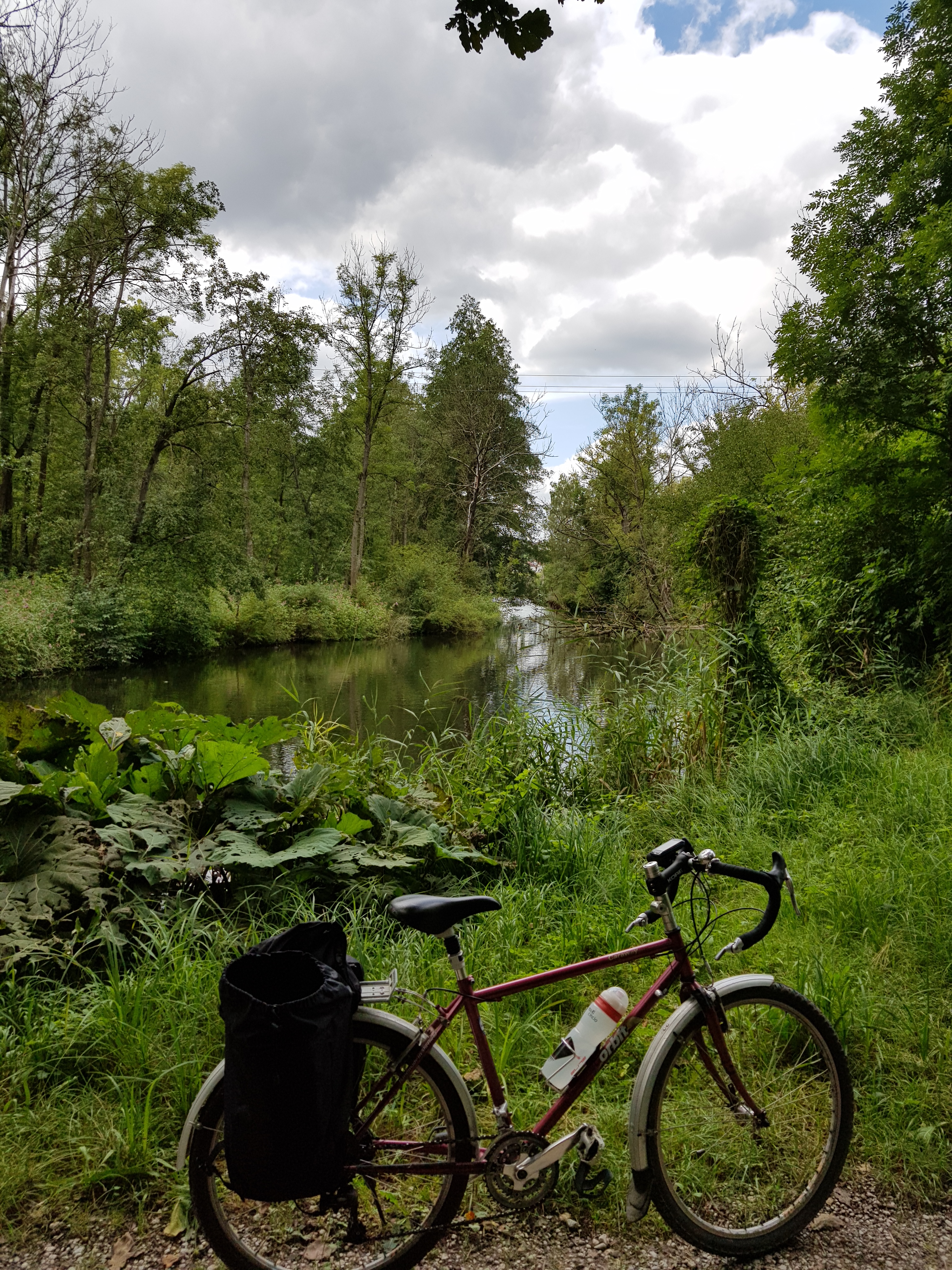 enjoyment. But I suggest that riders persevere because the route does eventually move away and the peace is restored. There is a lot of water; not only the river, but also many pools (left), at least one of which (very close to Würmmühle, supports leisure swimming (it has a pontoon and steps to access the water). There is also a lot of forest; on a hot day, a good forest can be really cooling and also dampen any sounds that might be coming from planes or the nearby motorway.
I made it to Kranzberg but failed to see any directions towards Allershausen, so I opted to follow a sign for hikers 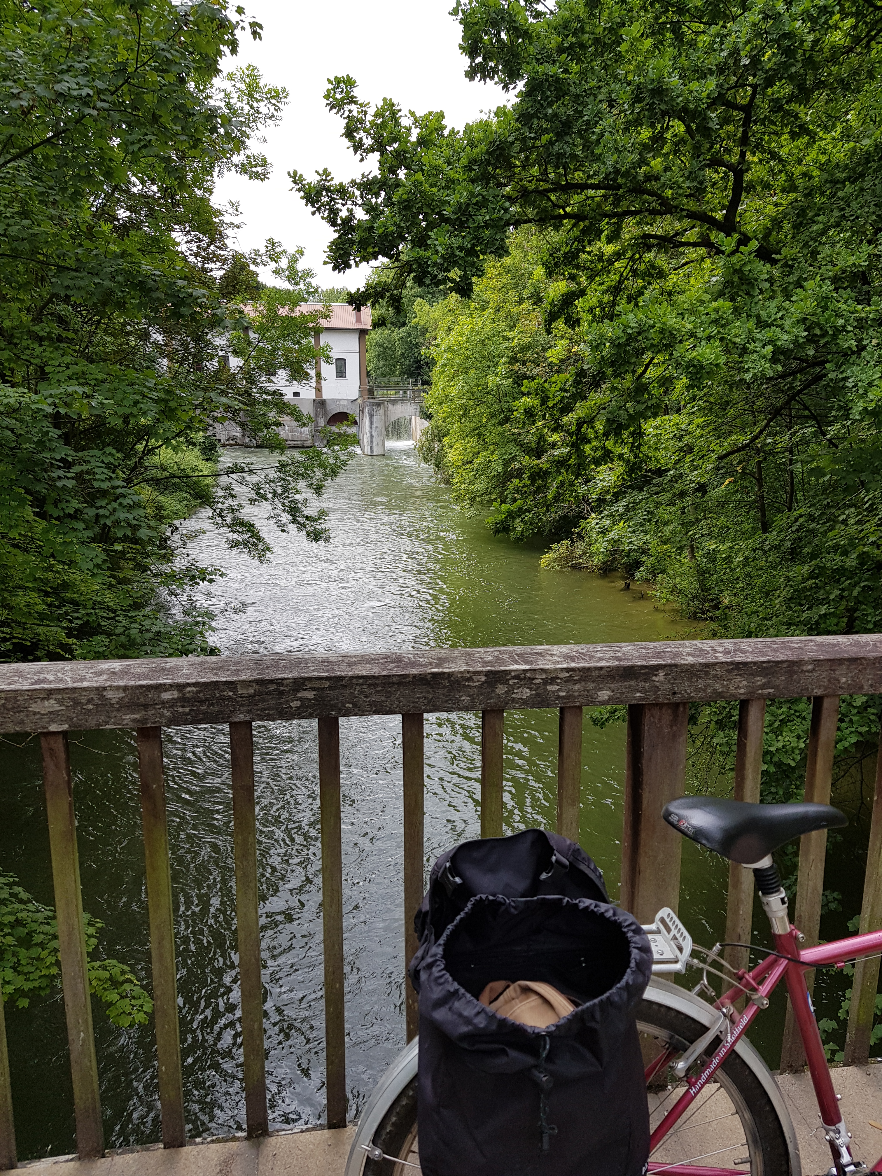 directing them towards Freising. Not a bad idea, though the path ran out at Giggenhausen (5km short of Freising). A bit of road had to be done; though it was not too bad. Freising is nice. Good decision.
So today, I went back to Dachau and took the southern route. I had intended to follow the route all of the way to Eching and then move on the Herrsching where I could pick up the S-Bahn. It was not to be for a number of reasons. Though a key one was finding myself on the wrong side of the river necessitating a bit of tracking back to find a bridge. Many of said bridges are wooden (right close to Olching). Plenty of picnic places, but not many other 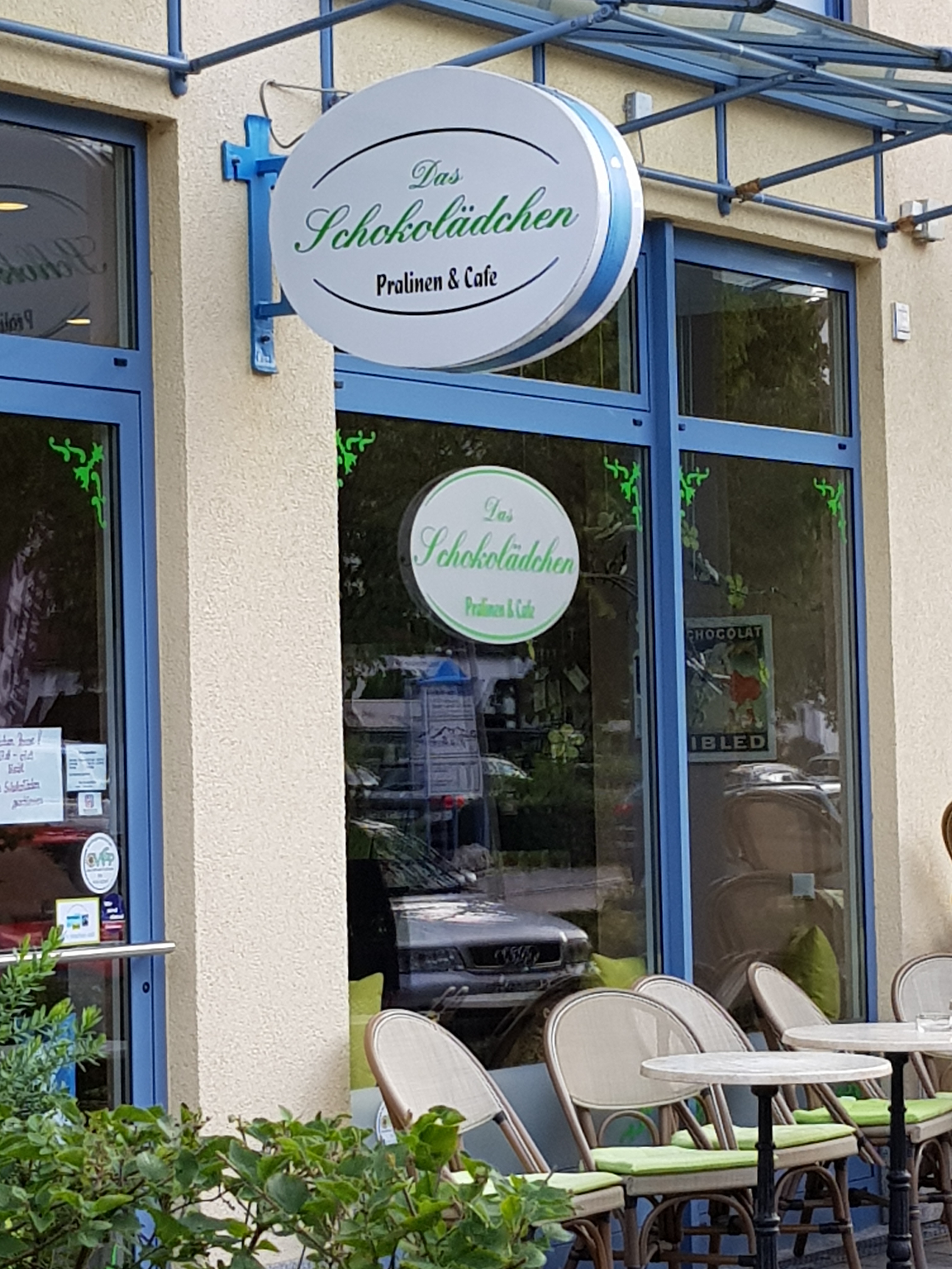 eating opportunities. I found one Gasthof that was open (Gastätte Amperlust).
The southern route is much like the northern route. There are also some aeroplanes, though they are a little higher. There is lots of arable land to navigate. Plenty of forest, too. I only managed as far as Fürstenfeldbruck (40 kms from my starting point). Eching was signposted as another 22kms and Herrsching maybe 10-15 beyond that. With the time available that was too far. So I took a path to Munich via Aubing. And as ever, one finds things that one does not expect. For example, Puchheim, wonderful cafe/chocolatier (left with coffee at €1.60!).
Finally, there is always the thrill of industrial archaelogy. Now, it is quite normal to demolish buildings that are old or are no longer useful/functional. So to come across a large, derelict industrial building is unusual and quite exciting. I have no idea what it was, but it was worth a picture (right). It does look like it will be demolished shortly.
Tandem Tour 2018 Part 5: Dürnstein to Klosterneuburg/Vienna
 I reluctantly observe that very large cruisers have replaced the barges along the Danube. They have their own particular bulky cargo that is decanted at points along the way. The towns and villages adjacent to the berths have spikes of activity as the visitors arrive en masse. So it was with Dürnstein, across the river from our campsite at Rossatz. It looked gorgeous at night illuminated, but the central area at peak time is congested. There are gift shops galore. And plenty of attempts at flogging of the local wine. We did find a bakery for breakfast, but even parking the tandem safely and out of the way was a bit of a task. Incidentally, just a little way out is a cyclists’ cafe, probably a better option.
We’d also been advised that the path on the north side was really nice. We can confirm that the south is probably better through Mautern rather than Krems. Krems has a historic western approach, but once the path reaches the prison (which riders cannot miss), then it is downhill from there. The path is incoherent and actually quite difficult to follow. We took the first post-Krems opportunity to cross the river back to the southern path over a relatively new bridge in the direction of Wagram where the cycle track is built under the roadway (right).
We think we were right to revert to the southern path. We found ourselves in a riverside restaurant at Traismauer, suitable for lunch. 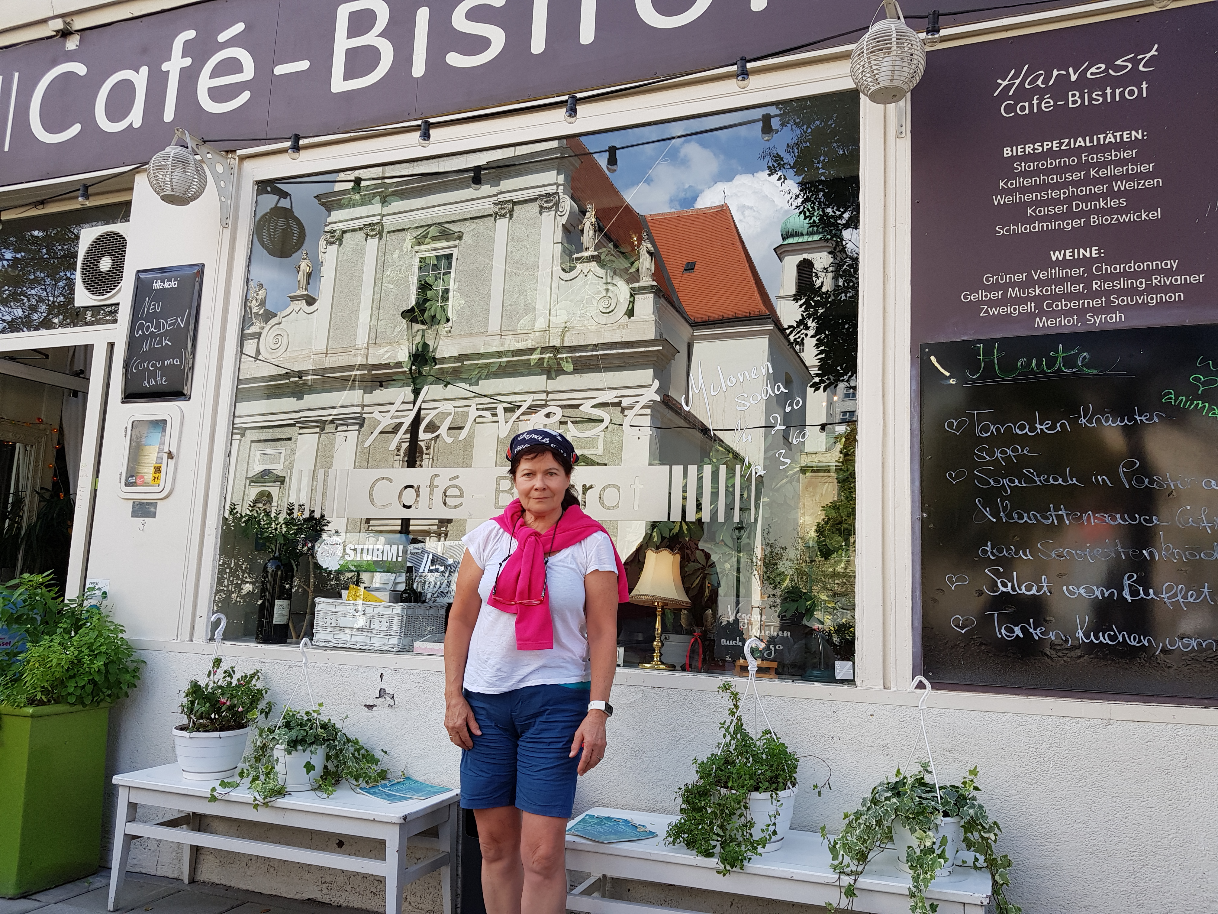 Then all very quiet until Tulln which is quite a resort. There is a camping site, a live stage floating on the river and a multi-activity park. As well as a bakery, naturally. It is also, as we noted, at the end of the S-Bahn to-and-from Vienna. It might not be a bad place to base oneself. However, we decided to go further to Klosterneuburg which is very much a suburb of Vienna. Another 20kms further and, by this time, we were feeling it. But Klosterneuburg has a great camping site, frequent trains to Vienna, and its own very particular brand of restaurants and cafes (including an icecream parlour where ridiculous quantities of icecream are loaded onto a way-too-small wafer cornet). It is fun to watch and delicious to eat. But impractical.
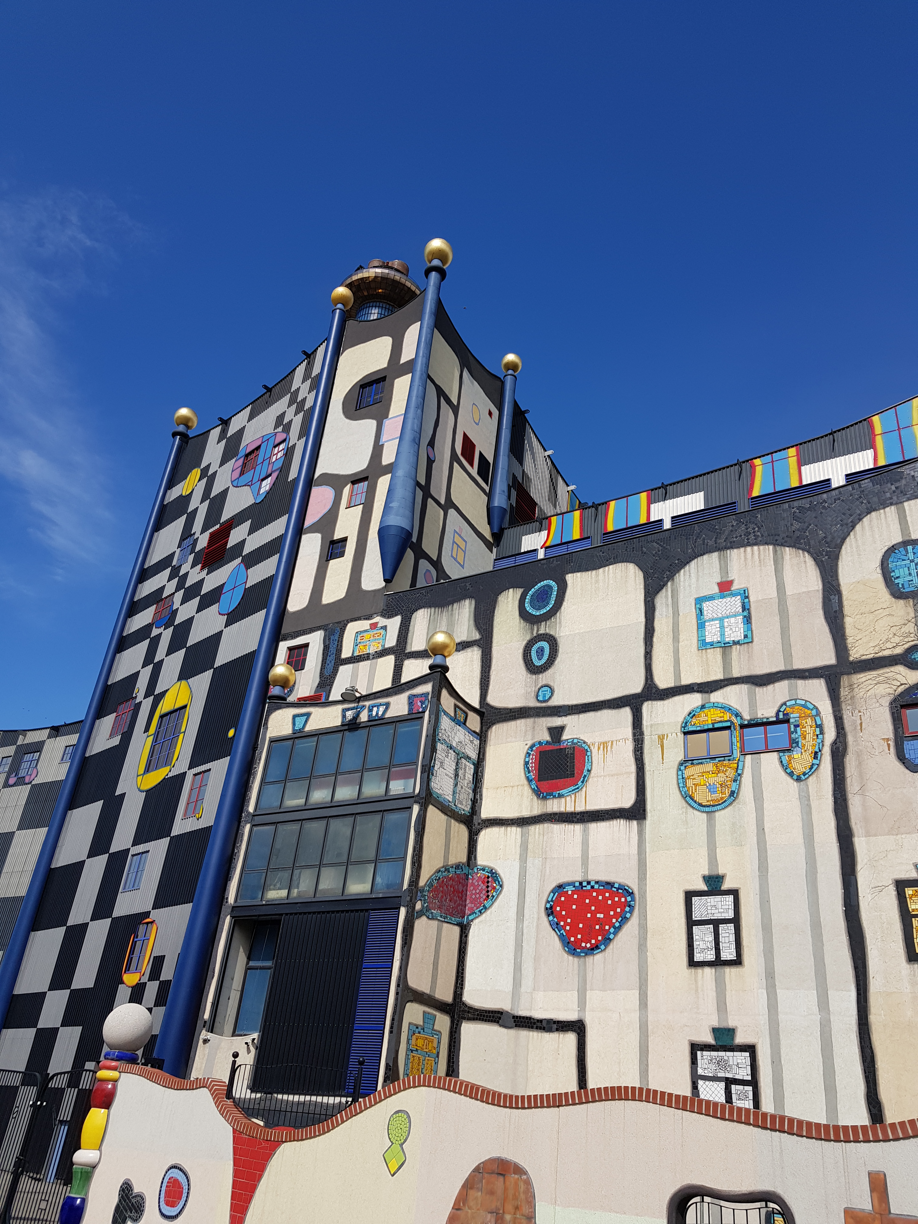
 We took two days out in Vienna. The tickets by train to – and around – Vienna currently cost €9.30 (taking in trains, Underground, tram and bus). We visited a cafe that we had failed to get in during previous visits; namely Harvest (above left). We also visited the Jewish quarter and came across Rachel Whiteread’s holocaust memorial (right). A signature concrete construct with books to symbolise both knowledge and, of course, the Nazi penchant for book burning. It is fitting and just-about works. All of the Nazi death camps are listed around each of the four sides. Chastening.
 Vienna is truly a gift for anyone interested in architecture. Whilst there are plenty of examples of imperial architecture associated with the Habsburgs, there is also quite a bit that is – and was at its time – rather challenging (particularly to the establishment). But eventually became accepted and then celebrated in the city. Take, for example, the Postsparkasse (left) built in 1904-12 by Otto Wagner. It is an imposing building and is not fancy apart from very small nodules being placed perfectly in vertical and horizontal lines. To see them, readers will need to click on the photograph and then enlarge. It should not work, but it does.
Wagner’s art nouveau and modernist architecture is not in short supply in the city. Wagner was a founder member of revolutionary artists’ association, Vienna Secession. I suspect our next visit will take in all of these buildings in turn. Apparently we will be hunting down a number of residential properties, railway stations (U-Bahn) and the Danube Weir. The Postsparkasse is, clearly, not art nouveau, but apparently it is a masterclass in modernist interior as well as exterior. Seemingly everything from radiators, counters to desks and door handles are worthy of note.
For readers wanting to get back to Munich, we can report that the operator of the rail route between Vienna and Salzburg (Westbahn) does not 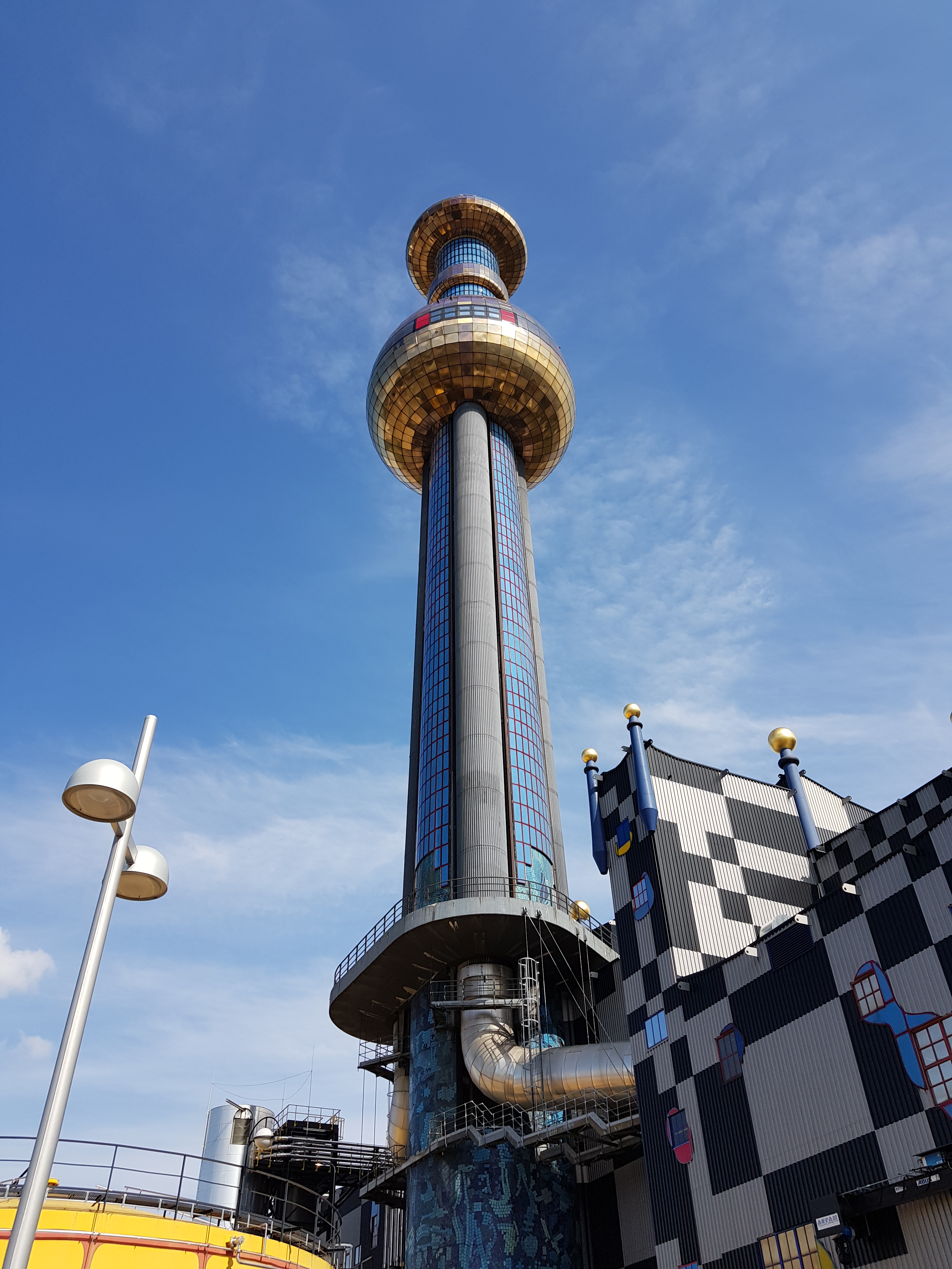 accept tandems. So we had to come back with OBB and Deutsche Bahn via Leoben. Not the most direct route, and certainly not cheap. There is dedicated cycle space, however. It was wonderfully scenic. The ride in to Vienna to get to Hauptbahnhof took about an hour. The path takes riders past Hundertwasser’s power station (right) and then further along the Danube canal to Schweden Platz. From there one needs help as Hauptbahnhof is not well signposted. We resorted to Google Maps.
Tandem Tour 2018 Part 4: Ottensheim to Dürnstein
 In light rain we continued along the north path towards Linz. We decided not to cross the river into the city, but rather to shelter under the entrance to the Information centre in Urfahr (the partner town to Linz on the north bank). An hour later we moved on in light rain.
Deceptive sun, Linz
There is no functional path on the south because of a sizeable industrial area. It can be viewed from the north for those interested in such areas (myself included; the river’s frequent hydro plants are extraordinary constructions). As we hugged the bank of the river the weather improved. At Abwinden the path moves inland for a short way, through St Georgen and rejoining the river at Langenstein.

Rural idyll. A quiet Danube
We took a break at Mauthausen; the town’s Nazi history – large labour camp and its satellites – is confronted in memorials, activities/seminars, etc. Austria was annexed by the Nazis in 1938. This part of Austria had a significant cluster of labour camps where prisoners (many of them non-German) were worked, in many cases, to death in quarries, mines, munitions and aircraft factories.
Then on to Au, where there is a campsite, with “Badesee” and other water attractions. The tranquility of this stretch is wonderful: the Danube at its best. It is easy to make progress on the dykes. Inland again through Mitterkirchen. The sun was by this time dominant, though on the approach to Grein we met both a road and railway. The campsite is located on the path to the south side of the town.
Grein is a lovely town. In the market square one finds the Town Hall and a host of cafes and restaurants. Sunday night is a shade limited. We went to a sort-of-Italian restaurant (with significant Greek influence on the menu, Pizzaria La Vita) frequented by locals and campers. We had not fully accounted for the Austrian laws that do allow smoking in restaurants. This place was like going back in time in the UK. The fug was extraordinary and the environment unpleasant. Sitting outside was not an option because the temperature had dropped significantly.
For breakfast we started at the bakery in the marketplace (smoke free) and then to the Konditorei on the bank of the river for a second coffee. There is in the town a fantastic bicycle shop. It reminded me of childhood. Everything had a place and it smelled of oil – bicycle oil, that is. Marvellous. My beloved bought a new cycle jersey that smelled, until it met with some soapy water, of that bicycle shop.
Across the ferry to the south side where the track was again dedicated. Beautiful in the sunshine, tree-lined and hugging the river. Not too many refreshment options before Ybbs. There we found another baker’s shop and ate outrageous (by which I mean large and full of gooey nice stuff) pastries and coffee in the sun.
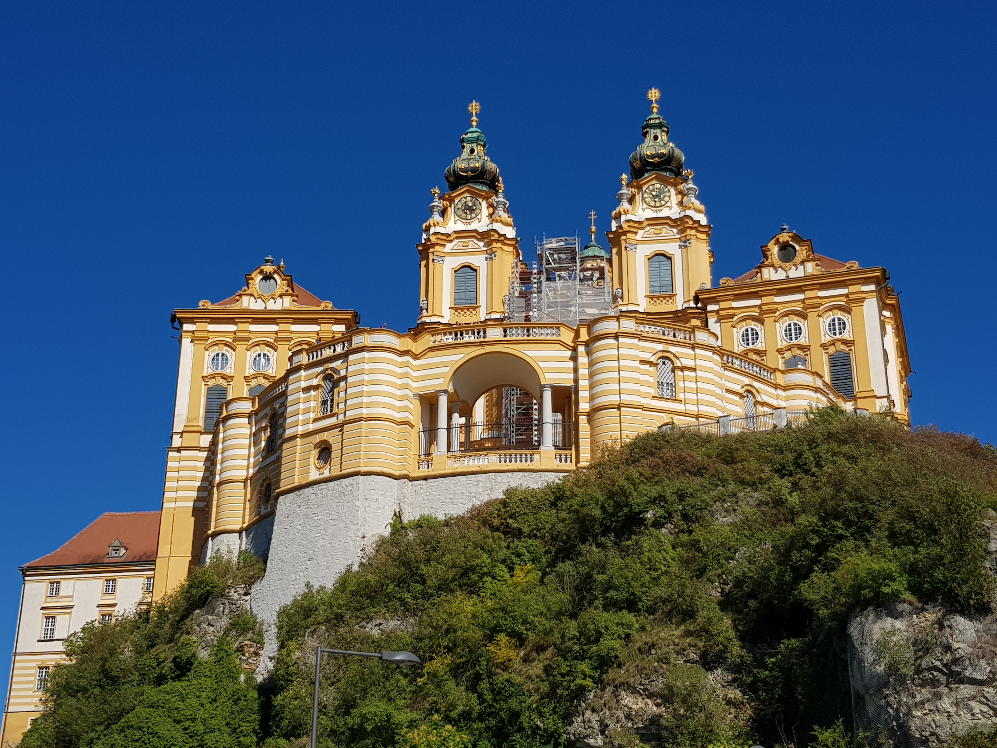 23 kilometers further through the vineyards and orchards is Melk. This is always a reminder that, whilst I may be on holiday, many people are not, especially the migrant workers who harvest the grapes. Lots of migrant labour is in evidence, trying to earn money for their families, let alone a holiday. I should not need to be reminded.
We half had a mind to stay there at a campsite on the river just short of Melk. We were slightly put off by its location, adjacent to a mooring for large cruise ships – industrial scale holidaying – of which there were five already decanting their load on to waiting coaches. Plus, we were feeling fit and up for a little further in what turned out to be a sunshine-blessed day. From a distance, the monastery at Melk is visible; it is imposing and against the backdrop of blue sky, worth a photo (above left). But we were soon on our way.
The path is quite challenging at this point. The valley becomes very steep – there is a bit of climbing to do on the road close to Schönbühel. Slightly beyond that is Aggstein. The Gasthaus there has a nice garden. We stopped for more food (locally-grown pumpkins are very much a feature of Gasthaus menus in the area, so I opted for Kurbis soup). Then finally on to Rossatz which really just emerges along the route. It is a curious campsite – patches of grass on the roadside, but it was a suitable end to the day, and the night-time view across the river to Dürnstein (right) seems justification enough.
Tandem Tour 2018: Part 3 – Passau to Ottensheim
 We had breakfast in Passau Market Square before recrossing the Danube to follow the track on the North side. It follows the main road until Obernzell. One needs to be patient. From there it is dedicated cycle track to – and beyond – the border (right).
We stopped at Niederranna at a dedicated cycle station (cafe) and did a bit of tent drying in the breeze after  overnight rain. We decided to stay on the north path and take the ferry over the river to Schlögen (below left). The north path beyond this point is converted into a ferry ride as the river bends back on itself in what is a particularly picturesque spot. We thought that, because of the distance for the day, we would try to do a shortcut from Schlögen to Haibach ob der Donau and cut this section. Shortcuts area always good in theory, never so good in reality. Out of Schlögen we had to climb 300m on the relatively main and bendy road. With our tandem that was quite a challenge. We then missed the road back to the river at Haibach. We carried on towards Hartkirchen and then eventually to Aschach. We saved kilometers, but probably not time.

View from ferry to Schlögen
From Aschach the path is again dedicated. It began to rain heavily. There was a marked campsite on the south side of the river near Ottensheim. It turned out not to be there. We were forced, then, to seek shelter in Ottensheim itself. We used to car ferry to do so. A great ferry that uses minimal fuel by using the current and a cable slug across the river. The motors are intermittently powered to provide momentum. Our guide recommended a hotel in the marketplace. It was full. We carried on out of the town for a couple of kilometers to Rodl where we found a campsite with a Gasthaus opposite. The landlady was brilliant. She made us some veggie pasta supported by a glass of Zweigelt.

Finally at the peak near Haibach ob der Donau
The site provided cover in a hut with electricity, sufficient for us to sit and read for a short while. The rain continued into the morning. It lightened whilst we showered.
Tandem Tour 2018: Part 2 Marktl to Passau
 The first night under canvass is often not the best. A working farm, of course, invites an early cockerel, bleeting sheep and, of course, tractors. But after breakfast in Marktl we followed the Inn cycle track to Passau; a curious place where three rivers meet, often too enthusisatically (right).
View of Passau heading east along Inn
The route itself is quite rough in places. There are long stretches of shingle on dykes zapping energy. The river also has many tributaries. This makes it an ideal river in which to swim; and indeed, there are frequent “Badesee” – areas for swimming, sunbathing and having lunch. This contrasts very much with the Danube where we found few places to swim safely.
We stayed on the north side of the river in Gemany. The river forms to border with Austria. At these times of tension around migration, this is significant. At Simbach, for example, there is a border check on the German side. And yes, brown people were being checked.
The route takes in few towns and villages, so if refreshment is needed, the south – Austrian – side may be a better option. For example, we were getting a shade hungry and thought we might find something in Neuhaus (about 20km short of Passau). We rode 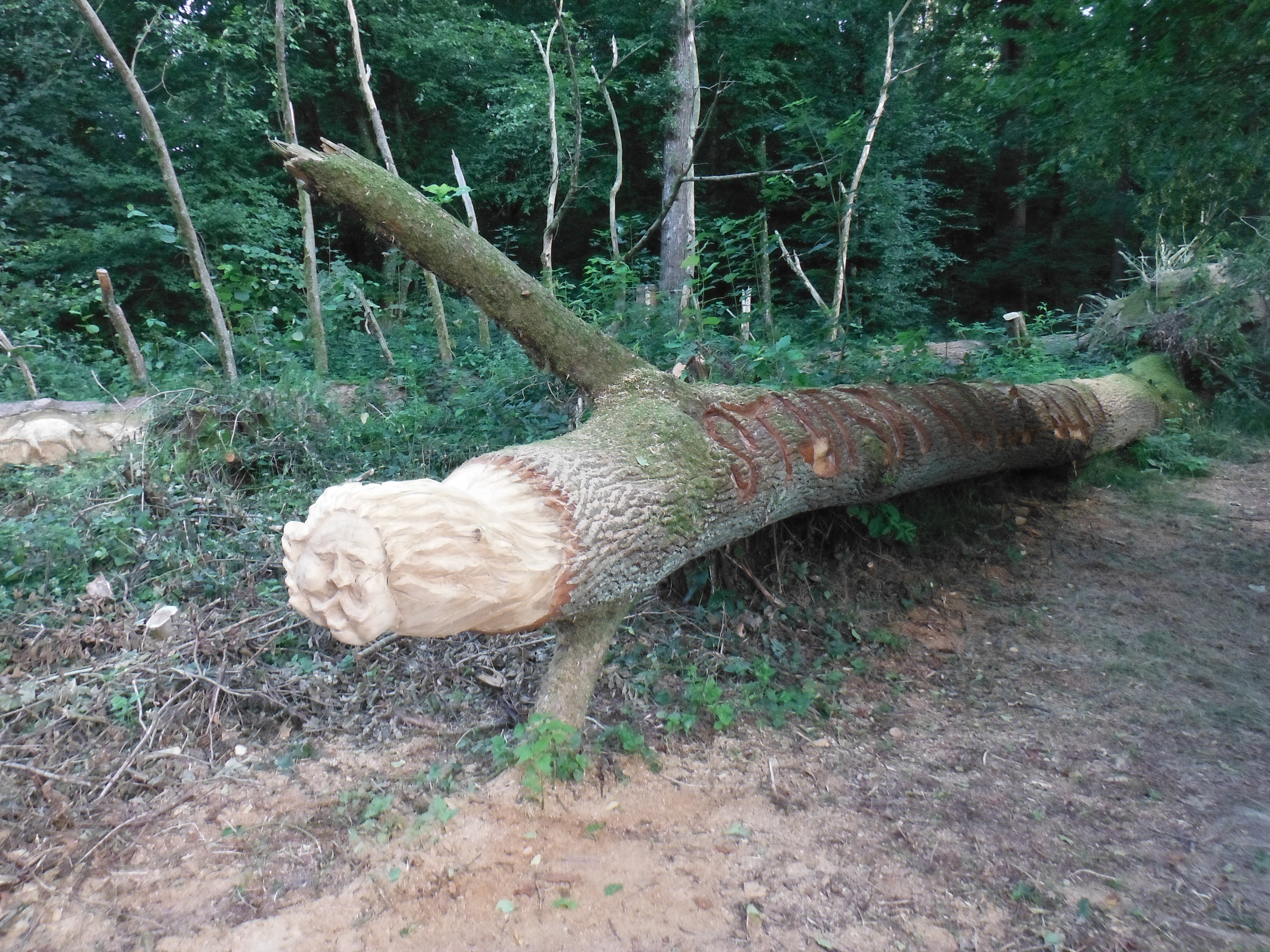 through finding nowhere. We think that we would have been successful if we had crossed the river in the Austrian town of Schärding. Actually, a little further on we found a welcoming bakery in the village of Vornbach (there were lots of cyclists already there). It is also worth stopping there because the final few kilometres into Passau are quite challenging. There is a climb into a forested area; it is
  bendy, dangerous (steep drops are possible) and rough under the tyres. It is also exquisite. Some creative soul has carved some faces into felled trees (left). There is also a wonderful wooden bridge (right) over the Rott at Weihmörting.
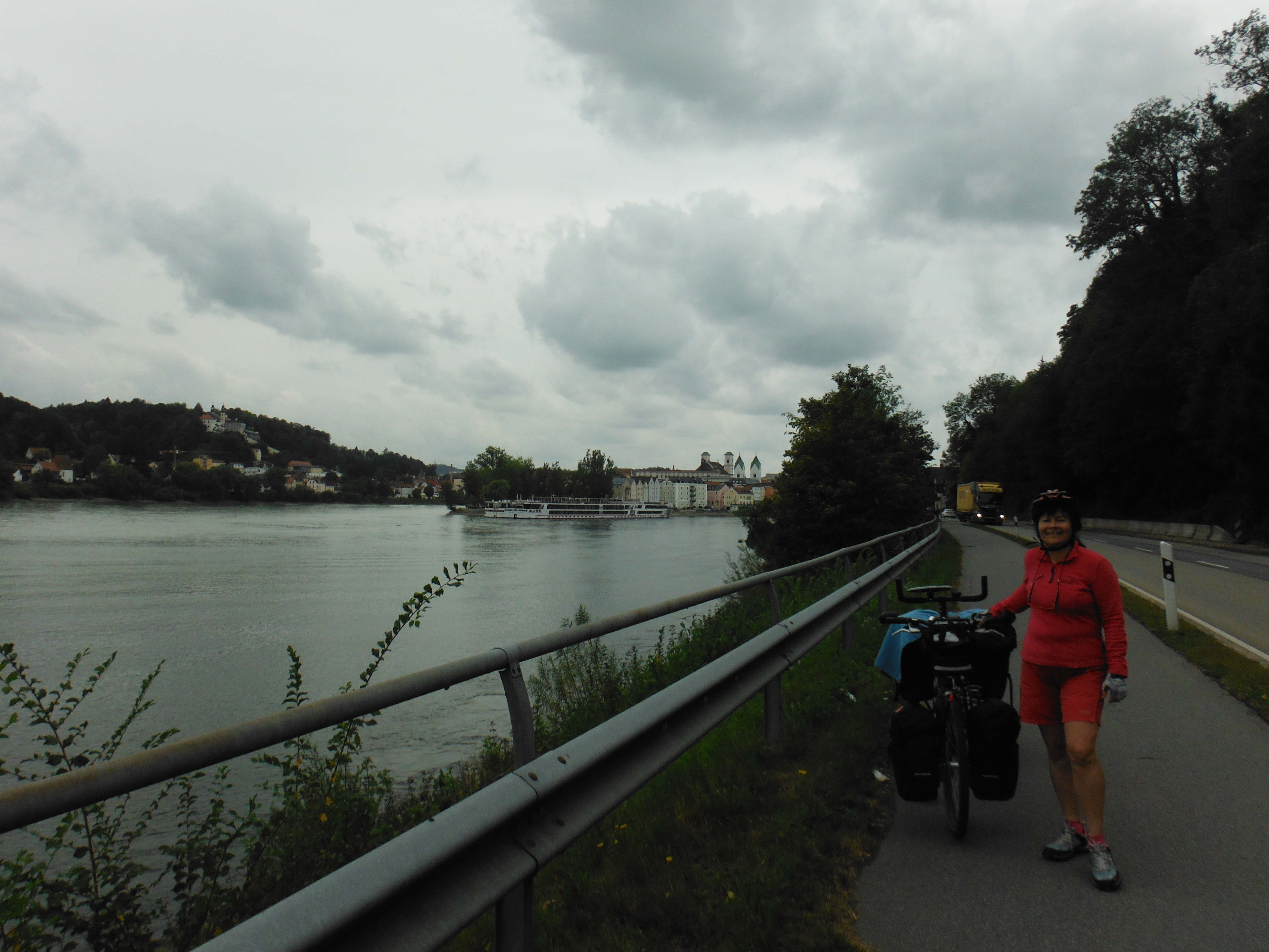
On arrival in Passau, we immediately had to work out which river was which. The campsite is on the Ilz to the North. The route to the campsite in the end was quite simple (and signposted), but when one is tired, it does not seem so. There is a significant road that leads towards Hals which has been carved out of the rock; it is certainly not designed for cyclists, but it’s the only way.
We ended up with a day of 80kms. We decided to pause for a day in Passau. It is not a big town. It has an old town – the Danube cruise ships offload in this part) – with a fine cathedral, squares and cobbled streets. The regular town with the familiar retailers isfurther to the west. We ventured there really only to find a bank.

Campsite, Passau
The campsite (left) is directly on the river Ilz. It has a good toilet block with a washing machine. Dotted around the site are clothes drying frames. At first we thought that a lot of people had somehow brought them with them! However, the true gem is the “restaurant” adjacent to the reception. It looks like a takeaway, but dig a little deeper and one finds some brilliant authentic Italian cuisine. It is so good, that we ate there twice, despite the opportunities in Passau.
Tandem Tour 2018 – Munich to Vienna – Part 1, Mühldorf to Marktl
Hunderwasser’s power station, Vienna
Regular readers will know that Vienna is one of my favourite cities in Europe. It is home to some great art, architecture and cafes (never underestimate the importance of the cafes). We have been twice so far this year, so the decision to cycle from Munich to Vienna for our summer tour this year was easy. There is that famous river, the Danube, to follow using largely dedicated cycle tracks. There’s sufficient – conveniently-located – campsites.
We’ve been off the tandem for a couple of years arising from various self-inflicted injuries on increasingly ageing bodies. Last year my back protested – though we salvaged the summer with a bit of trekking (not the most obvious response to a back injury, I know). The previous year we did our Tilman Riemenschneider odyssey.
So, having avoided injury, we checked our gear. I decided to upgrade my sleeping bag in line with my partner’s. I now have a Mountain Equipment Helium 250 – suitable for summer use. It is very light (254g) and packs very small. We also replaced our Salomon Goretex shoes – we were expecting some rain and wet feet are always unwelcome. I went for another pair of Salomon X-Ultra, whilst my partner tried a CMP trail shoe. Other than that, all seemed in order.
We took the train from Munich to Mühldorf which is approximately 100km from Passau on the river Inn. That would give us a total ride distance of about 450km (for a couple unsure about fitness and stamina this year, that seemed far enough). The train on this route has space for a tandem, and travelling off-peak in the middle of the week, we managed to have the cycle carriage largely to ourselves. There are suitably-sized elevators at Mühldorf to get from the platform to the main street without unloading the tandem. So, in the first day arriving late afternoon, we made it to a working-farm campsite close
  to Marktl, the birthplace of former Pope, Josef Ratzinger. There is a museum in his “Geburtshaus”. Perhaps more importantly, there is one restaurant in the town, an Italian. The baked vegetables were interesting. We managed breakfast at the cafe in the marketplace, where the nearby pharmacy bears a mural eulogising back-breaking work in the fields (left).
The annual tour serves a number of purposes. It tests – and develops – our fitness. As people who work in a sedentary environment, keeping fit is not so easy. Being away from that environment with a machine that only works if one puts energy into to it, reminds us of our limitations – or our capabilities. It also helps to think about resources more generally. When I first started cycle touring back in the 1980s, there were no electronic gadgets that needed charging. I had a manual “mileometer” and a (camping gaz) cooking stove. This year I took my mobile phone, but did not turn it on (not least to avoid emails and other social media for 10 days).

Cycling along the River Inn – tracks are often rough but usable
We focused on keeping the Garmin Edge 800 navi charged using a now-ageing “Power Monkey” (charged where possible using sunshine, and if not a power socket at a campsite). Any spare charge went into my partner’s mobile which we used to find a posting box for our postcards, public toilets and to navigate to Vienna’s main station, Hauptbahnhof. We fuelled ourselves with a good breakfast (from local Bäckereien or Konditoreien); Apfelstrudel and some bizarre but good offerings from Gasthäusern or Restaurants. All vegetarian food seems to be open to interpretation.
Tandem Tour 2015: Kitzingen to Bamberg via Sand am Main

The main route heading north and east is a delight.

It is still significant enough to experiece ferries and sizeable bridges, some of which riders are required to use. We travelled in a northerly direction towards Dettelbach. This is very much wine country and Dettelbach (below right) is twee and offers a considerable – and probably necessary – marketing opportunity for growers. They have hostelries on the road side with opportunities to sample the local wine and  then buy a crate. We acquired a taste for Domina (a fruity red) and Spätburgunder (another word for Pinot Noir). Suffice to say, we did not carry a crate on the tandem.
We actually stopped at Volkach for lunch where, clearly, we should have stopped at the St. Maria im Weingarten church, the home of another Riemenschneider carving. But we hadn’t done our homework. However, by way of compensation, and as is so often the case, one 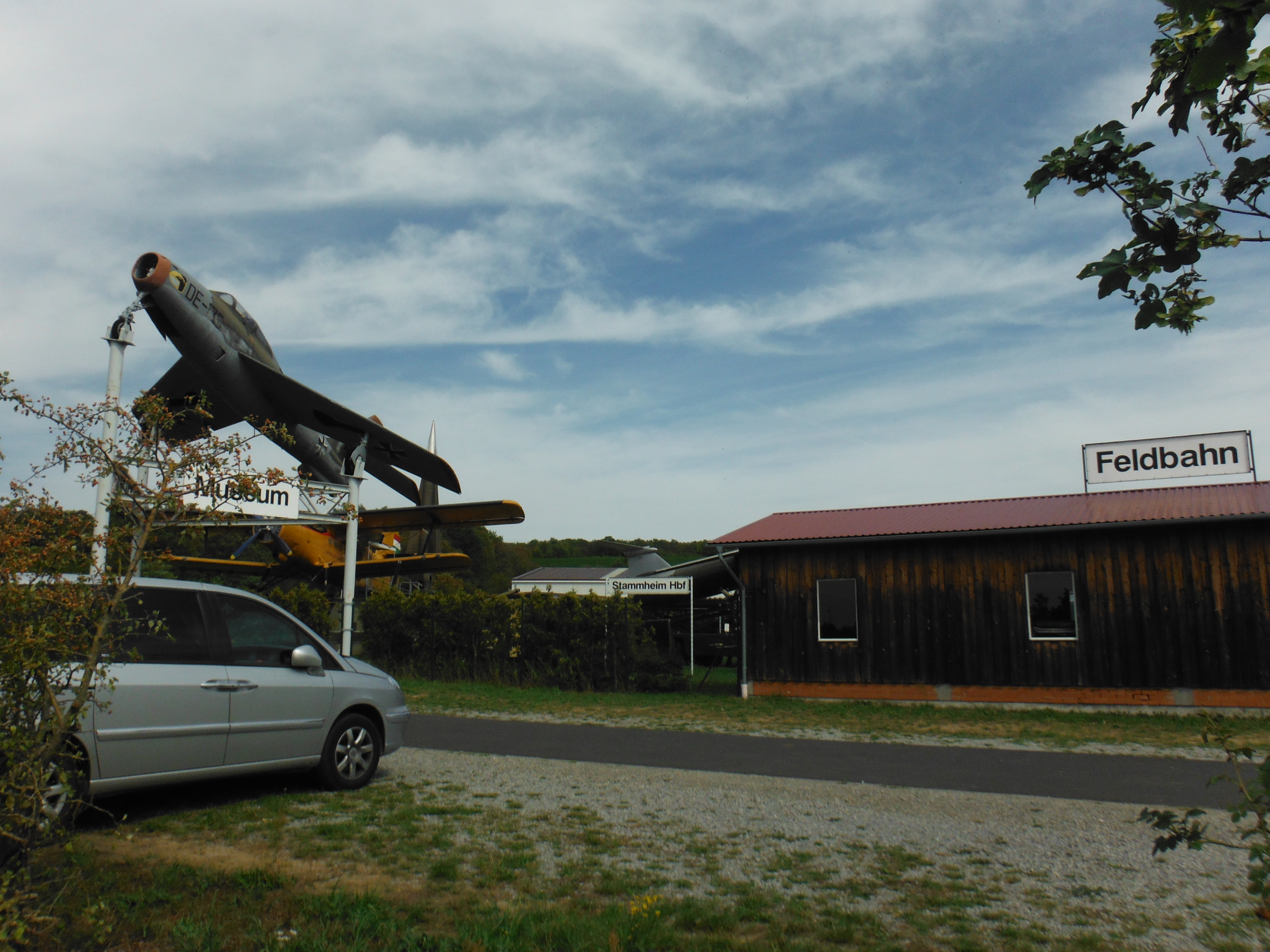 stumbles upon strange – sometimes inexplicable – attractions. So at Stammheim, one encounters an air museum (left). And a ferry. I love ferry rides across rivers (below right).
Onward towards Schweinfurt which is a not insignificant industrial town. It produced most of the Nazi war machine’s ball bearings. For that reason it was a target of allied forces in 1945. It retains significant metal industry facilities. But if one follows the track, the city is largely bypassed.
Next up is Haßfurt, again somewhat bypassed. We were keen to get to our preferred campsite at Sand am Main. We took a little detour adjacent to an airfield, surprisingly busy with small and micro aircraft. Sand am Main proved not as easy to get to as we might have thought. There is a lot of water which requires one to ride over the correct bridge just to the east of Knetzgau. The campsite is actually on the banks of Sanderbaggersee and is, consequently, relatively easy to find once in Sand.
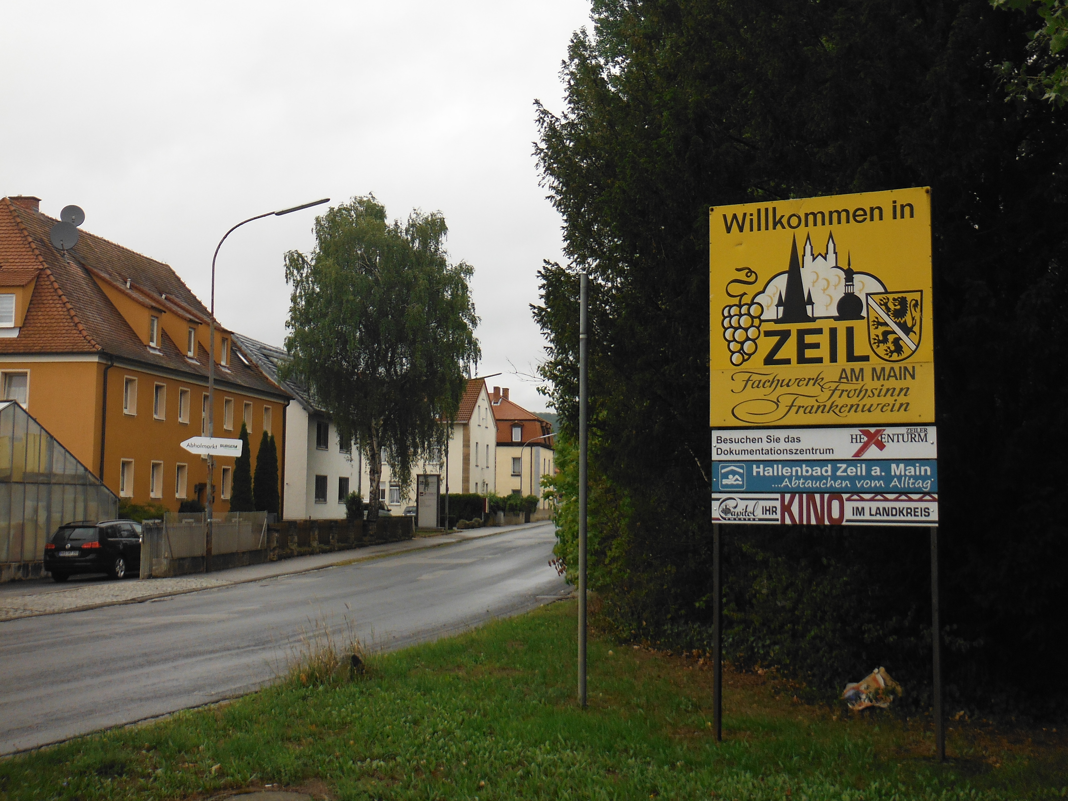 Time for a day off from the tandem. The next day we walked into the nearby Zeil am Main (left), a centre for furniture manufacture, and caught the train into Bamberg. Bamberg – or at least its centre – is a UNESCO World Heritage Site. And it is extraordinary. It has a thousand years of history, much of it religious. It lost its status as a city state in 1803 becoming part of the Bavarian kingdom.
It is certainly a hilly place (there are 7 hills, die Hügel), thus enjoying the architecture requires some strenuous walking. The stone used for the buildings gives it an unwarranted industrial feel. The Cathedral (right) is, for example, built from a sandy-coloured stone, as is the nearby Michaelsberg Abbey (below right). The cathedral dates from the 13th Century and is described as romanesque (Bamberg is often described, inappropriately, as Bavaria’s Rome). As for the  interior, one can find an ornate Riemenschneider tomb sculpted from marble (left). It was sculpted for Heinrich II and his wife (Kunigunde), and dates from the early 16th Century. It is adorned with carvings capturing a series of complex stories. For example, Kunigunde was challenged on her faithfulness to the King
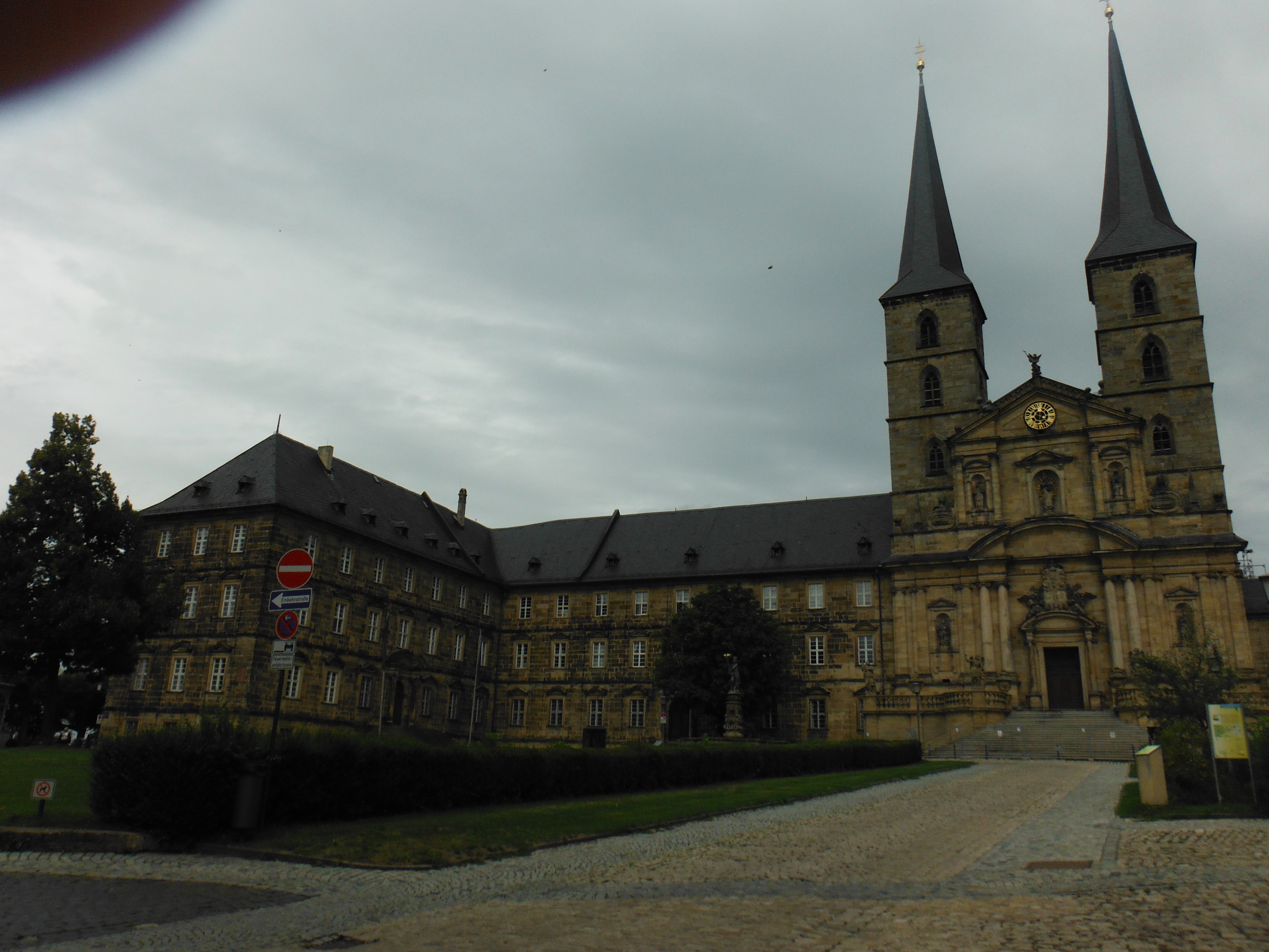 (left). She was essentially cleared after proving her faithfulness by runing over some hot sharp metal without injury!
Bamberg also has a history steeped in beer, not unlike most Bavarian towns, it has to be said. There is one very special beer, however, that had to be tried. That beer was Aecht Schlenkerla Rauchbier (essentially, dark smoked bier). The beer is smoked arising out of an 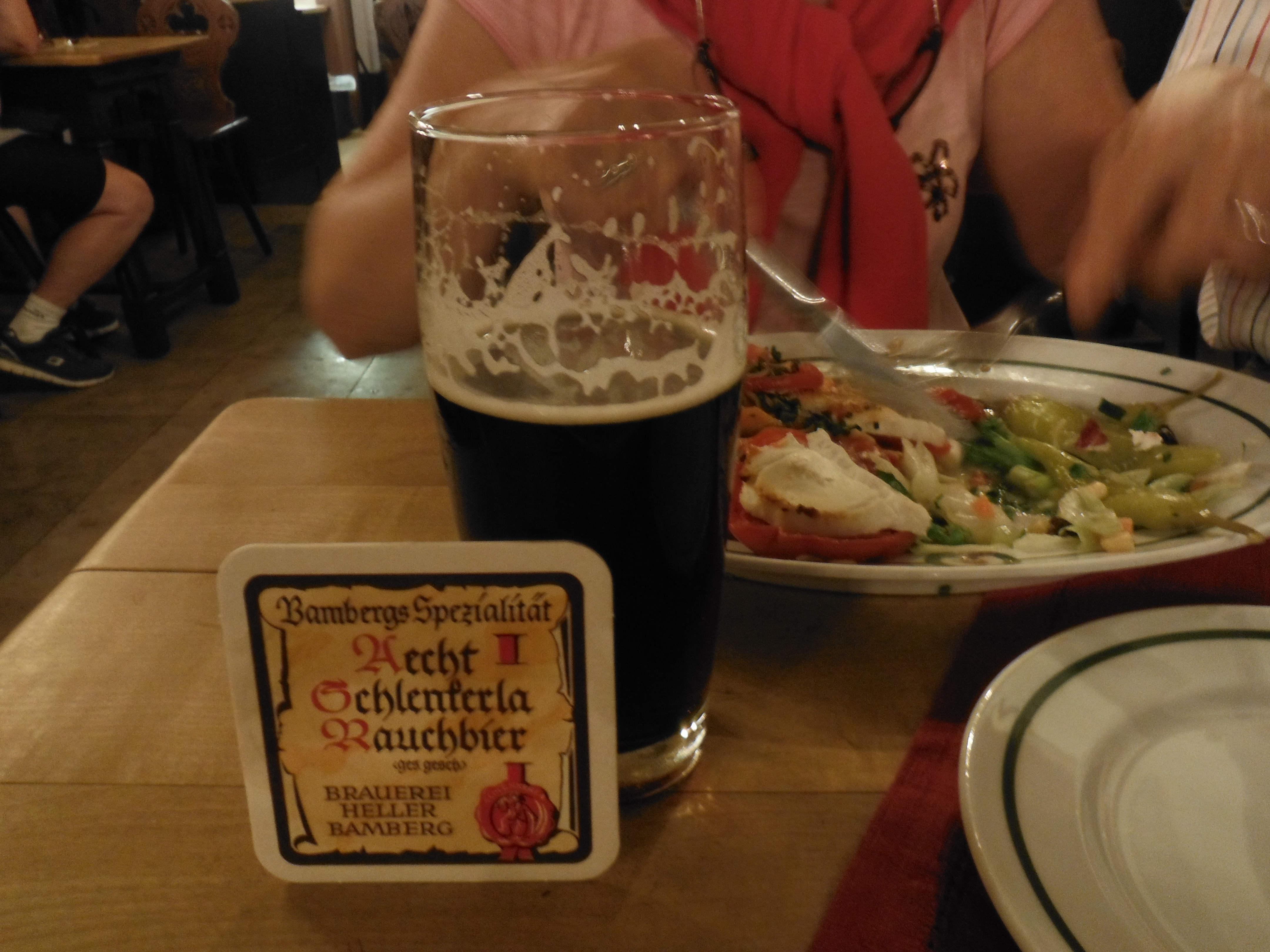 accident. Fire damaged the brewery and soiled the ingredients including the hops. However, waste not want not, as-it-were. The next batch of beer had, not surprisingly, a smoked flavour. I have to say, one glass was enough. The hostelry itself offers traditional complementary food which is quick (the turnover inside is rapid) and surprisingly good, even for a vegetarian.
Tandem Tour 2015: Tauberbishofsheim to Kitzingen via Würzburg
 Rather than go all the way along the Tauber to Wertheim to join the Main, we decided to go direct and take what is known as the Romantic Route linking Werbach
 just north of Tauberbishofsheim and Würzburg via Alterheim. The route is well signposted (right) but, as a route it is not as well developed as the river routes. Essentially, treat it like a motorway with no services on it. Take food and water because this is not an easy 30km or so. That said, Werbach to Würzburg is easier than the other way around. The gradients are kinder. Not surprisingly, it is also much quieter.
When Würzburg arrives, it is fantastic.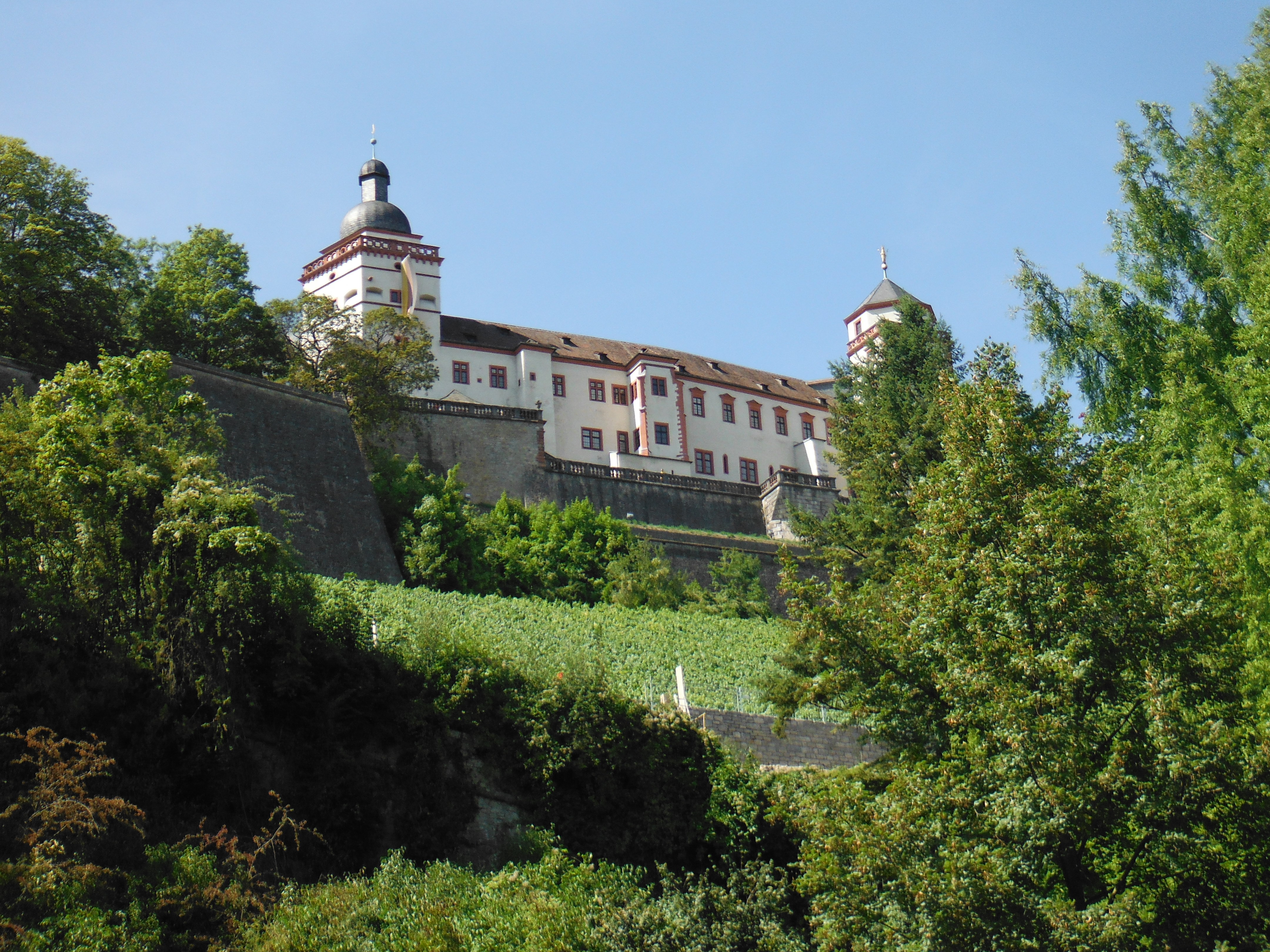 The Fortress Marienburg (left) dominates the skyline and the city centre is as architcturally rich as any in the region. Though it is also a working city where the tourists are contained.
The Würzburger Residenz is a UNESCO World Heritage Site originally built between 1720 and 1744. The Rathaus (right) is a 14th Century building, but like the historic centres of many German cities it was severely damaged by allied bombs in 1945 (a firestorm on 16 March 1945 killed 5000 civilians). Fittingly, much of the historic centre was rebuilt. The Cathedral, moreover, has two examples of 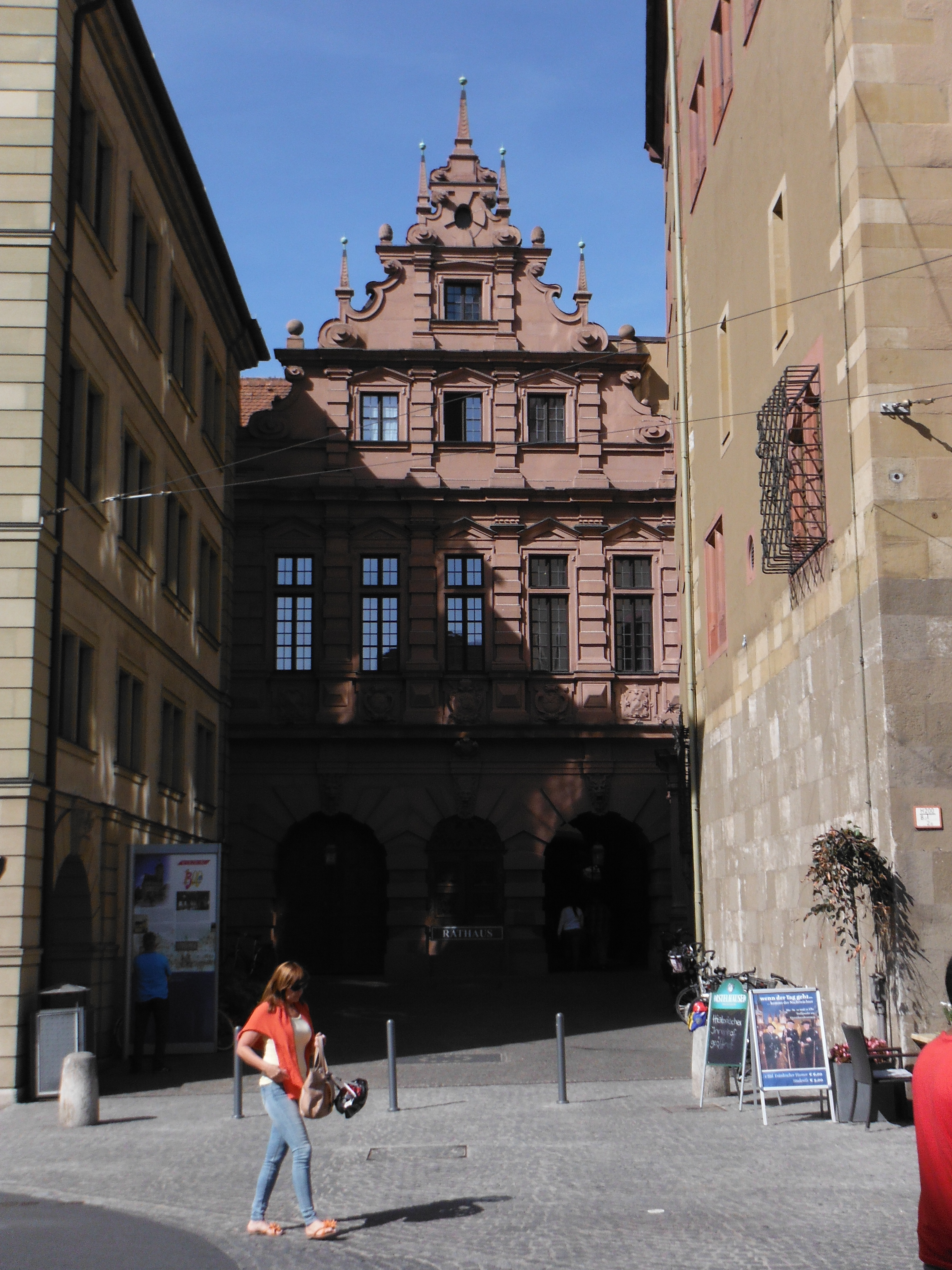 Riemenschneider’s extraordinary carvings.
We ate well at the Ratskeller before heading to the river and following the Main Radweg to Kitzingen. This takes riders principally through the historic town of Ochsenfurt. Just short of Kinzingen is the excellent riverside campsite. Kinzingen is another picture postcard town, the history of which is closely related to the Church, Würzburg and Napoleon.
 Breakfast opportunities are considerable. It is also very cylcle friendly. First of all, if one has an e-bike – of which there are many to be seen on these cycle routes – there is a charging station. But more interestingly, there are secure luggage lockers (left) for cyclists!
Tandem Tour 2015: Eichstätt to Tauberbishofsheim
 Breakfast is usually in some Konditorei in one of the many towns. Coffee and freshly made bread with jam and cheese fits the bill nicely. In Eichstätt we found one on the cycle route out of the town.
The next section is has a lot to recommend it. The cycle route shares a railway line in the valley as it passess through Dollnstein and Solnhofen (a major part of the local economy is stone – stein – this influences many of the place names). Further on is Treuchtlingen. In the Kurpark, one finds the seemingly incongruously located steam locomotive rather forlornly dumped (right). The town itself was having a siesta when we passed through it (to be fair, it was very hot). But ultimately it is an old market town famous for handcrafts and silk. The aforementioned railway link to Ingolstadt and Munich, built in 1869, was key to the town’s industrial development. But there is a further significance, the railway station was bombed on 23 February 1945 by the allies. 300 people died on one train in the station. Maybe the forlorn locomotive fittingly commemorates that terrible event?
 A little further along the river is Gunzenhausen, a resort on the Altmühlsee, a large inland lake (left). We camped there, breakfasting at a cafe on the shoreline. We then continued our tour north west towards Rothenburg ob der Tauber through Leutershausen and Colmburg. There is a bit of cross country to be done here and if you suitably miss the path,
 as we did, you can be diverted into villages that show some of the eccentricities of the Bavarians relating to their gardens (right). I cannot quite remember in which village this scene of life and fantasy was discovered. But it made the detour worthwhile.
 A little further on, we found another village (left) that was not quite looking its best. I was expecting a sign saying something like “sorry we are not looking our best, come back in 6 months…please”.
We found ourselves in Gasthof zur Krone having coffee and Apfel Strudel in Leutershausen (the Gasthof kitchens in Bavaria are mostly closed between 1500 and 1800, there is little hot food to get). The landlord told us that rain was forecast for around 6pm and if we wanted to make it to Rothenburg before it came (we were keen to get the tent up before it set in) then we should take a short cut. The road that was recommended seemed rather substantial (st2249). But in the event, largely unused. A recommended detour. A bit more hilly, though.
And then Rothenburg itself. First we would say, if you want to visit the town, go direct. Do not follow the cycle track as it steeply descends into the valley and the way back up is tortuous. The town is significant in its history and is home to an amazing Tilman Riemenscheider alterpiece carving – something we discovered only on getting back and watching again Andrew Graham Dixon’s BBC documentary, The Art of Germany (though if we had read our guide close enough, we would also have known). Indeed there are many Riemenschneider carvings in Bavaria. We stopped off at two further churches containing examples of his work at Detwang (where we camped and pictured, above right) and a shade futher on the Herrgottskirche to the south of Credlingen on the L1005 (and don’t forget the Thimble Museum, below left).
The campsite at Det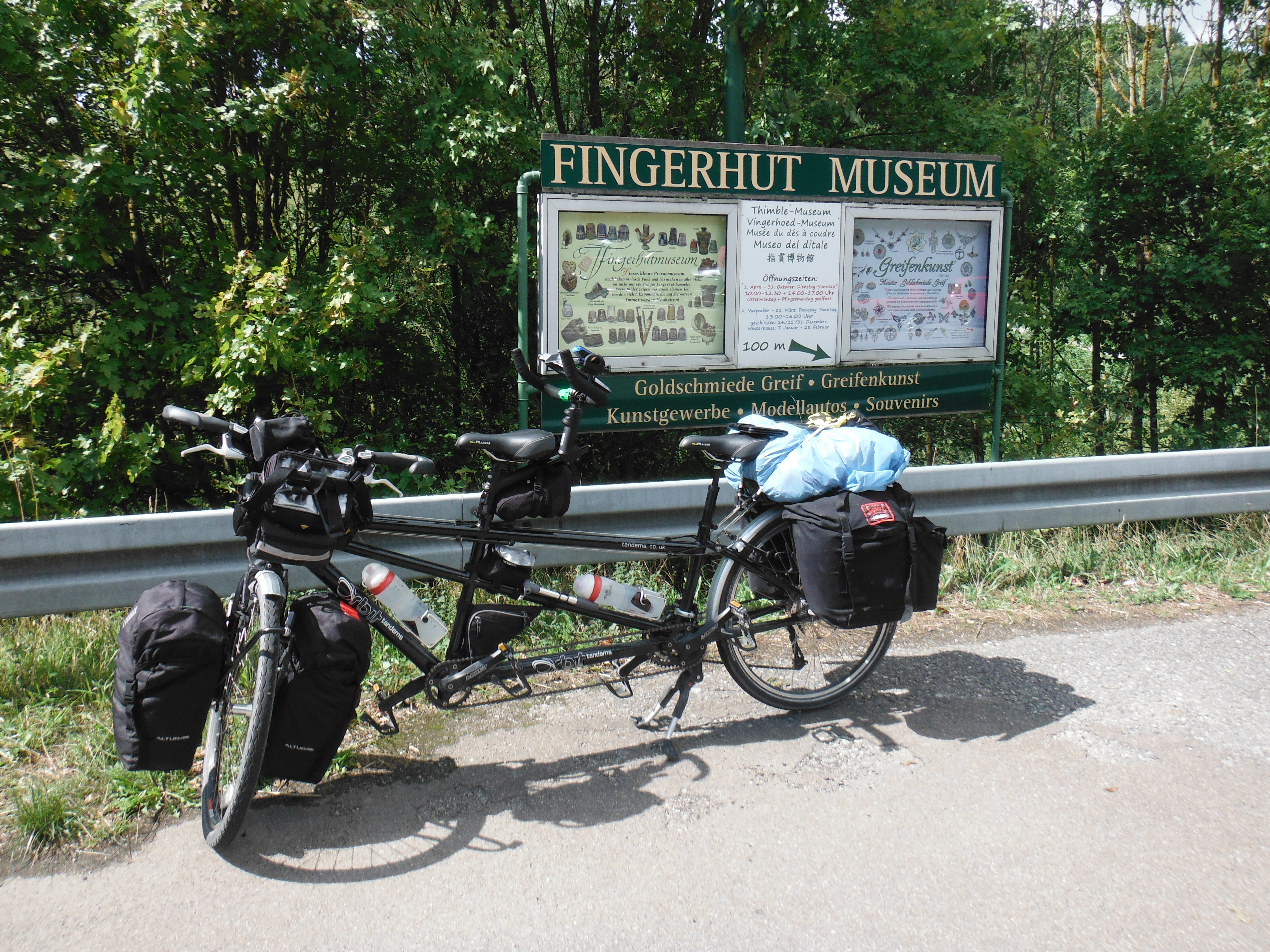 wang is described elsewhere. With heavy rain we abandoned any idea of getting into Rothenburg and elected to eat in one of the Gastätte in the village. Monday and Tuesday are closing days for one of the restaurants. We had, therefore, no choice but to go to the Gasthaus Tauberstube (http://tinyurl.com/o2yhwsy) despite a note on the door saying reservations only for the evening. It was great, though traditional food. They were well prepared to offer us something vegetarian. And we drank some local wine. The next day we met the landlord in another cafe in Credlingen – he was clearly checking up on the local competition! He recognised us even though we were on a tandem and wearing our gear. We have to revisit Rothenburg. I think we now know where to stay.
Onward towards our next stop, Tauberbishofsheim through the attractive towns of Röttingen, Weikersheim (right) and significantly, Bad Mergentheim. The secret to its fortune is in the name. The area is rich in mineral springs and was found to be particularly useful in dealing with digestive disorders. The town also boasts a medieval castle with baroque church. But significantly, it feels like a real working town. Indeed over this stretch of the cycle path one cross the border into Baden-Württemberg, a culturally different place to neighbouring Bavaria. As one pushes further along the Tauber towards the confluence with the Main at Wertheim, it becomes more industrial and less twee. It is no worse for that.
 Hence, one enters Tauberbishofsheim through a light industrial area; and whilst it is not unattractive in the centre, it feels much more lived in. There is no nearby campsite, though it is well frequented by cyclists as we discovered in the hotel in which we opted to spend the night.
Tandem Tour 2015: Regensburg to Eichstätt
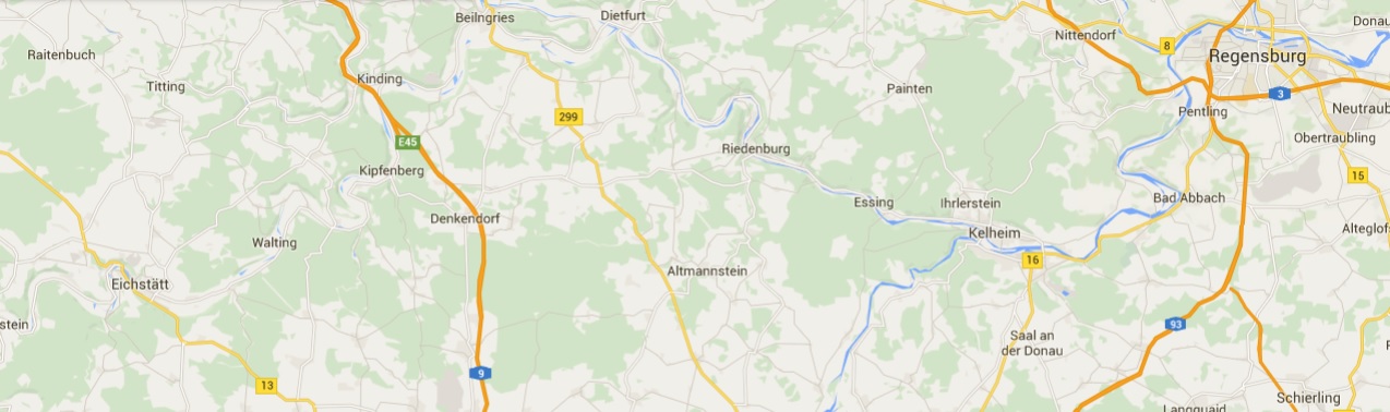 We took the train from Munich to Regensburg. The lifts at both stations are big enough to fit the loaded tandem. The signs outside the station immediately direct cyclists to the cycle path along the Danube in the first instance.
This section is picturesque, quite leafy and packed full of vertiginously perched castles and monuments. One should always be looking up as well as forward.
For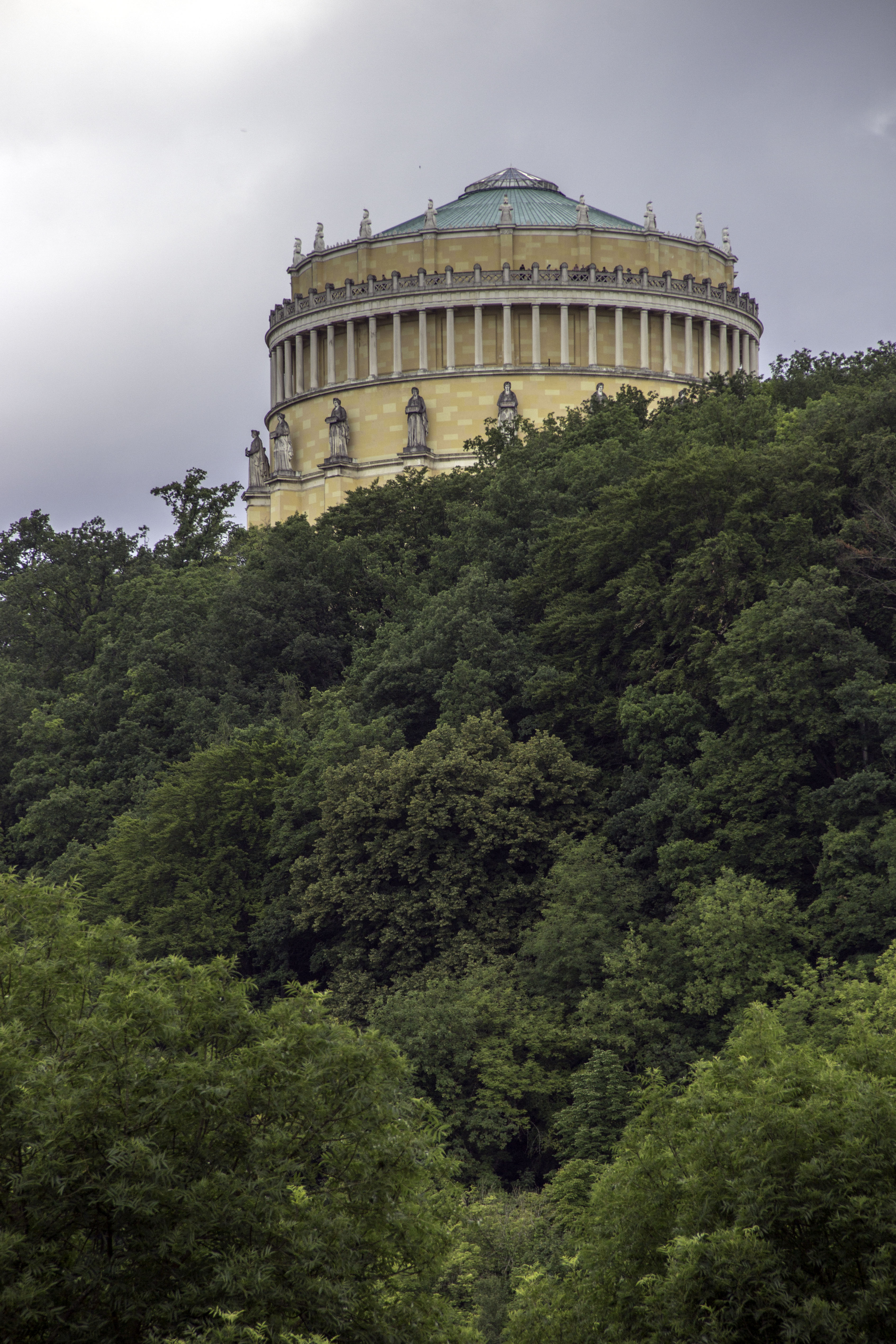 example, at Kelheim one finds the wonderfully curious Befreiungshalle (right). If my understanding is correct it is a after-the-fact monument to the defeat of Napoleon during the Befreiungskriege of 1813-15. The work on the monument itself was started in 1842 and completed in 1856 after a number of issues, not least the death of the architect/builder. It was principally funded by King Ludwig I of Bavaria. However, one should never underestimate the effect of French occupation of German lands on the country’s history. Monuments like this are not so unusual. I’ve used an image by (Wikipedia) because when we passed by it was shrouded in scaffolding.
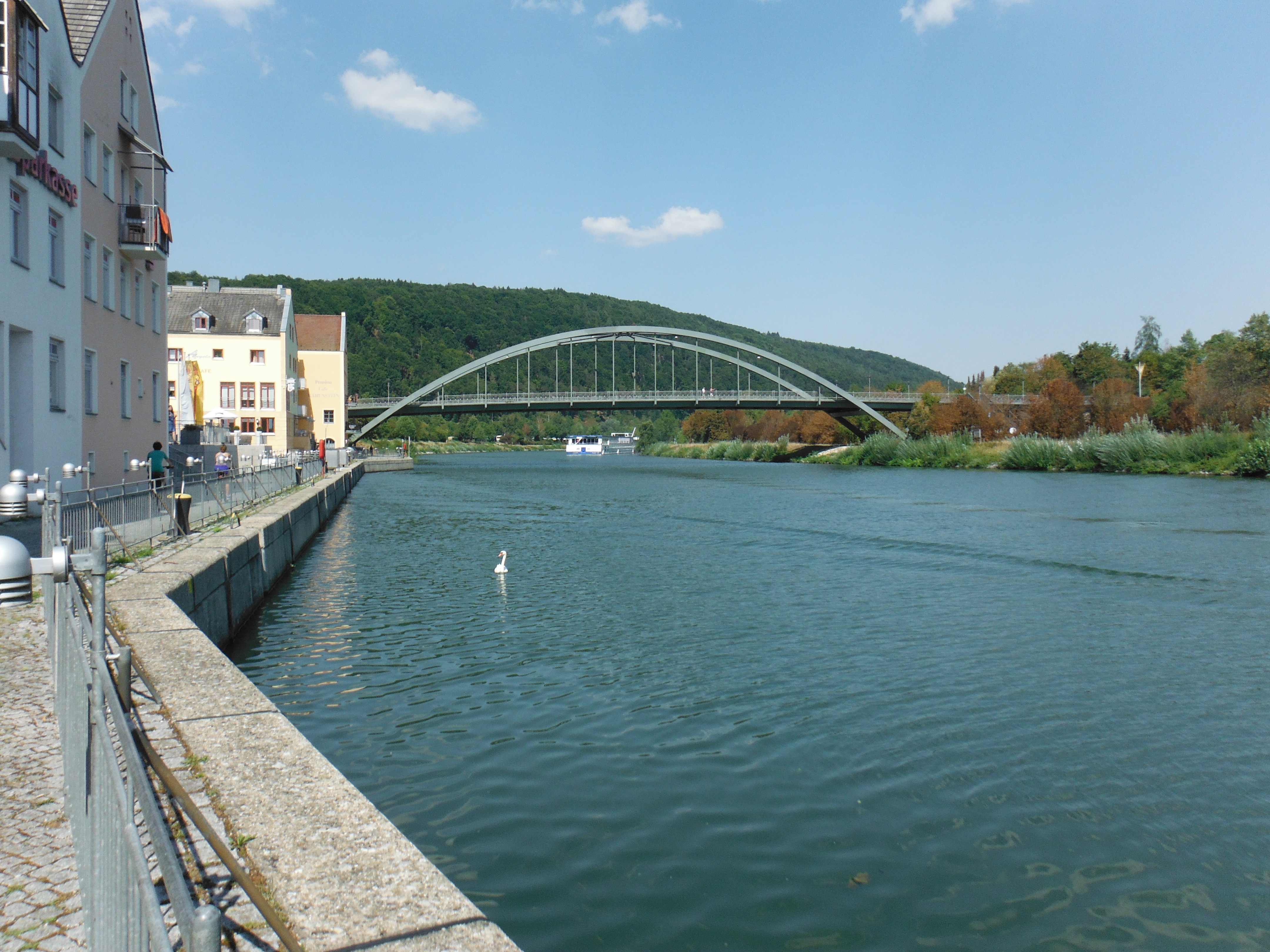 At Kelheim the Altmühl flows into the Danube. We were riding against the flow (and the wind). After camping at Kastlhof, we followed the river to Riedenburg (left) and Dietfurt. What one has to say about these places is that they are a shade generic. Dietfurt Rathaus
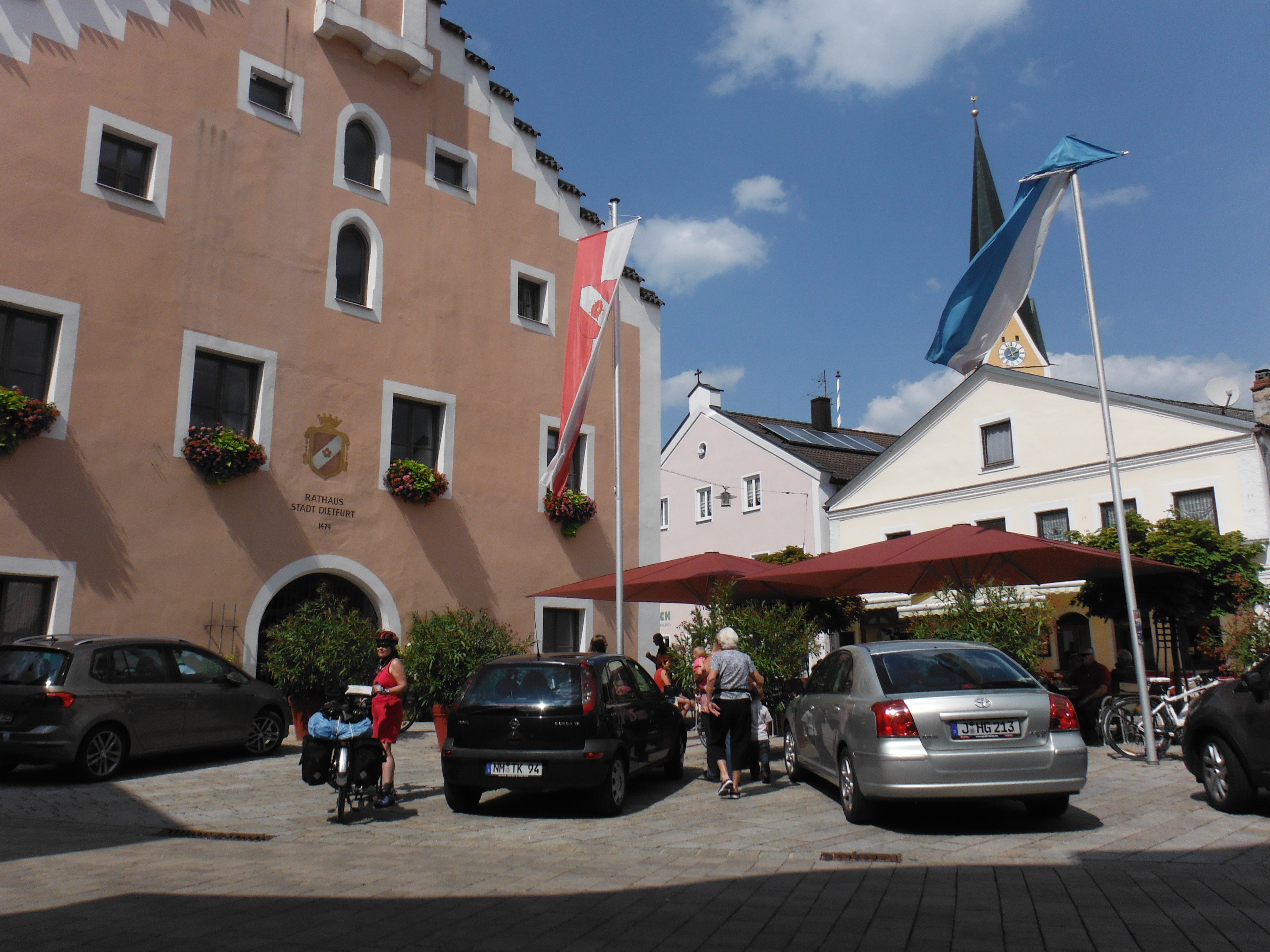 (right) is typical of the architecture of the region. And the Altmühl towns are, on the whole, very well looked after.
However, Eichstät itself is exceptional. A small town tracing its routes back to the 8th century BC with a cathedral, monestary (left) and a  catholic university is quite something to behold. I quite like the random sculptures in front of a nicely graffiti’d wall. Just a concession to demonstrate that even here, a white wall is too much to resist. The town is rather quiet in the evening out of university time.
